
Think of the First World War and you might conjure up black and white images of trench warfare from Northern France. This year has seen centennial commemorations for the anniversary of the outbreak of war in Europe. We saw the Tour de France take part with a route that passed memorials and battlefields. The dutiful ceremonies across much of Europe are important and remind us of the devastation.
But the war was fought across Europe and beyond and includes the Alps. Nothing offsets the devastation and loss of life but combat needs saw the establishment of new mountain passes and more accessible routes across the mountains. Today many roads used by the big races and cycle tourists were built out of a military imperative.
Some mountain passes have existed for thousands of years, a means for humans to cross from one valley to the next or even a obvious funnel for wildlife to do the same. But with the advent of human activity and trade more people needed to cross the mountains. But not everyone was allowed to cross and in time the mountains took on a defensive aspect, a natural block to invading armies, especially in winter. See Felix Lowe’s Climbs and Punishment for a sideways take on Hannibal’s crossing of the Alps.

Since then tribes and nations had fought in the mountains, the illustration above captures Roland’s defeat in 778 on the Roncevaux Pass in the Pyrenees. But it was really the advent artillery in the late 18th century that changed everything. A Frenchman called Jean-Baptiste Vaquette de Gribeauval helped issue common specification for cannons allowing them to be mass produced across France. His consistent set of rules for weaponry allowed more to be built and Napoleon went big on this, artillery proving to be an essential part of his successful strategy. But if infantry and cavalry could cross the mountains on rocky paths, these cannons could not. “Nothing is impossible” said Napoleon and by ambitious decree the mountains were opened up by a series of paved passes. Crucially these had even gradients and wide hairpin bends so that horse-drawn artillery could cross.
The Col du Simplon in Switzerland is a good example of a Napoleonic mountain pass, he ordered the construction of the route in 1801. This and other climbs shouldn’t be confused with the route taken by Napoleon on his return from exile, the Alps have a signed Route de Napoleon. Similarly Napoleon’s celebrated portrait on the Great St Bernard Pass (pictured) commemorates a crossing of the Alps when the artillery was broken down into component parts and men and mules were used to carry rather than wheel the equipment over the Alps.
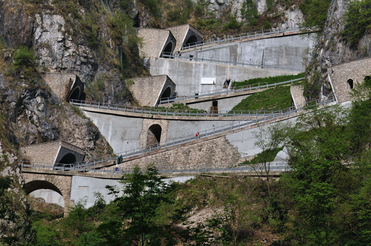
Today is Armistice Day in Europe and to commemorate the First World War we can think of the Passo San Boldo in Veneto, Italy (pictured at the top of the page). This was a steep pass but in 1918 a forced workforce of prisoners of war, children and the elderly were pressed into work for the construction of bridges and tunnels in order to make a more level ascension leading an astonishing piece of work with a series of hairpins built into tunnels, like some giant version of a child’s marble run. Wikipedia sums it up:
It is nicknamed the “Road of 100 Days.” Prisoners of war, the elderly, women, and children of the local population were pressed into service to build it. In its final construction phase, 1,400 workers worked in three shifts to build this strategically important connection. Despite the extreme topography, the requirement that the road be used for transporting heavy artillery and supplies meant that the grade could not exceed 12%
History like this reminds us of the hardship, free-wheeling through hairpin bends seems careless, flippant but at least something good comes out of it all. Other roads were built across Europe to service blockhäuser. A blockhaus was a military term borrowed from Germany in France, Italy and beyond to describe squad forts high in the mountains. The Col de la Bonnette at 2,715m is a useful case study. First used as a mule path it was widened by Napoleon in 1832 and declared an “Imperial Road” in 1860 at a time when many other roads and trails in the surrounding areas, like the Ubaye valley, were also subject to extensive military engineering. The existing route today isn’t Napoleonic but the product of the Second World War and France’s defensive preparations, with the Alpine extension of the Maginot line seeing military defences built high on the mountains between 1934 and 1938 with the roadworks following although they were interrupted by the outbreak of war in 1940 and fully completed until the 1960s when the Tour de France quickly visited.
Summary
War’s not good for much but many roads used by races and tourists, especially in the Alps along the Italian borders, were built out of military imperative for the specific purpose allowing horse-drawn cannons to cross the mountains over a period ranging from roughly 1800-1940.
Built for war, today the roads sustain more peaceful activities like sports, tourism and trade. The only battle is between you and gravity.
Photo credit: San Boldo Pass by Flickr’s Ole Holmbad
Great post! You nailed it with your comments about mules and triple chainsets. There’s just no way I’d get up any of these things without one (and sometimes I think about using a mule too) as I really don’t like to do the traversing done by so many undergeared riders. Never quite understood why so many want to have a bike “just like X’s” but don’t want to pedal up the climbs with the same cadence as their hero, instead struggling along with the same gear ratio – one too tall for them to turn easily.
“Blockhaus” is how the mountain-top dead-end finish above Passo Lanciano, on the Majella massif, is called. Despite the relatively low final altitude (about 2,000m) it has a very significant altitude gain, since you start at about 100m, and, what matters the most to me, impressive views since you’re quite near to the sea. It’s like a giant balcony. It was all paved to the top when I climbed it, but I think that recently they removed the asphalt from the last couple of kms, where the gradient starts to rise again. Absolutely worth a visit, especially climbing up the “hard version”, from Roccamorice (the Giro came here on various occasions, but only in 1972 they went up from Roccamorice: too many cyclists would rather walk than ride, since the gears weren’t the same as today).
I don’t know if it’s true, but apparently the name is derived from a fort built in 1866 during “dirty wars” between the official army of the new born Kingdom of Italy and *bandits*, rebels who wouldn’t acquiesce to the new situation.
That’s the Giro visit from 2009. As you say the German word has been used in Italy to describe the squat concrete fortresses rather than big castles.
Similarly, for military reasons this also applies to the Parisian boulevards, such as the Champs Elysee. I understand Baron Haussman designed them to enable the speedy movement of troops to quell any disturbances.
Disturbances: read riots from the Parisian working class (which had led to many a revolution!) Yes, that’s why we have these big avenues in Paris. And the places that still have small medieval style streets are where most riots take place when in Paris. (See Latin Quarter for ex.).
Ah, Paris!
Funny, I was just reading about Napoleon’s second Italian campaign, leading to Marengo, when many well-known Alpine passes were used (Mont-Cenis, Petit & Grand St-Bernards, Simplon, St-Gothard) by different French generals and armies to get to Italy, and still Napoleon arrived late to the decisive battle and almost lost it (and hence his subsequent attention to roadworking the Alps). One could imagine a nice race or cyclotouriste rememorating that campaign.
In Spain some of the most remarkable climbs (Pico Villuercas, Sierra Espuña, La Pandera, Picón del Fraile, La Salada) are actually military roads, leading to antenna towers, radars, or abandoned barracks on mountain-tops.
That route would be interesting, to Genoa… and then across to Cannes and then the Route Napleon back north through the French Alps.
Which is the kind of addition to a sportive that would make it stand out….
Your comment on the second image had me rolling on the floor. The image has all of the ingredients of many a local climb on a weekend morning. A hill, a battle and a fallen warrior and people loosing sight of the bigger picture in life. Surely this is the seed of a future post.
Ab. So. Lutely. Loved it.
The bucking mule and the jersey colors reminded me of some ancient “chaingate” 😉
Not only a great cycling read but also some history I wasn’t previously aware of.
As usual, your fine blog continues to surprise & delight 🙂
Great read. All too often military ‘necessity’ is the mother of invention.
Very cool article.
My olds happen to be vacationing in Sicily and they’re seeing some very famous roads and places from WWII.
Great post, as usual. Thanks. Now the pedantic contribution: Napoleon died in 1821.
Col de la Bonette: widened in 1832 dring the reign of king Louis Philippe and classified as an imperial road in 1860 under Napoleon … III.
Thanks.
I thought it could be him, the cousin. I tried to find more about the Col to check it, but couldn’t find any info. Again, thanks.
Great post. It is amazing how many military ruins can still be seen along many of these roads, whether they are old barracks (eg. Bonette/Restefond), bunkers, or more scenically, forts overlooking valleys below. Mont Cenis now has three newish little monuments near the Col sign: one for Hannibal and his elephants, one for Napoleon, and, happily, one for cyclists.
The French/Italian border almost all the way to the sea is filled with great, high paved/unpaved roads worth cycling.
Given it’s Nov 11th, the WW1 armistice day, the one place I’d add to your list is Monte Grappa. It was the site of serious fighting in WW1 between Austria and Italy after the Italian line collapsed at the battle of caporetto, reforming along ridges in the mountain. The mountain now has 9 paved ways to bike up – some brutally steep, all scenic. It is littered with old unpaved military roads, and ruins, and monuments, etc. And has the most impressive ossuary at the very summit – with remains of 43,000 soldiers: https://www.flickr.com/photos/willj/14280723923
The main road up is even named after the Italian butcher that led the Italian army for much of the war – the Cadorna road – he believed in uphill charges of entrenched positions. Nice.
War history buffs that like to cycle beautiful hors-categorie roads can pass an interesting if sobering time there.
Inrng,
Thankyou for another terrific piece.
Once again you show us why we readers of this site
are such devout fans of your work.
Every day ( almost ) I check in to read what it is here.
It always bring something interesting/enjoyable/thoughtful/not commercial.
Inrng,
How do you know everything?
No way, it’s writing about the topic that’s an education. I’d seen the forts in the Alps, remembered that the Col de Finestre – the unpaved climb to be used in the Giro – had a military genesis and thought the topic of military roads would be a good idea to investigate for the day. So it’s more starting from a position of ignorance and then learning a bit along the way.
Your inquisitive mind – and its results – are much appreciated!
Routes de Cretes in the Vosges is another good one, although I think this is a First World War road used to supply French troops along the Front Line in the region. I spent a couple of day there this year and not only is the riding great, but wished I could have spent a few more days there to explore the history of the region. We did pause halfway up the long side of the Gran Ballon at the Hartmannswillerkopf National Memorial for a quick look at it looked well worth another visit. http://en.wikipedia.org/wiki/Hartmannswillerkopf .
Since Will mentioned Caporetto (Kobarid in Slovene), there is a Vršič pass nearby Caporetto.
It’s the highest pass in Slovenia and for a long time it was also one of the hardest and longest climbs.
In recent years, some other climbs were repaired and covered with asphalt, so it’s lost some of its prestige.
It is definitely a road to ride in Slovenia. It is often included in the Tour of Slovenia.
Nearby is Mangart saddle, the highest road in Slovenia. In vicinity there are many forts, but all of them were built before WWI and weren’t used in the war.
Anyway, road on Vršič pass was built in 1915 by Russian POWs. Work conditions were brutal and there was an avalanche killing many workers. So in remembrance POWs built a orthodox chapel, now called Russian chapel.
Thanks, tempted to visit Slovenia next summer as it has plenty of roads and cyclists too.
if youre interested in wars & mountains, maybe also look up the swiss “réduit” it was a strategic plan during the second world war to retreat all military personnel and equipement to the mountains, not seldom INTO the mountains themselves. they built not only streets but huge fortresses and underground barracks and hospitals into the rocks. (actually italian workers mostly did the job) there were hundreds of them. in recent years they declassified most and if you have some cash at hand you can buy one or just silmpy go visit them. especially in the gotthard area are lots of them.
http://en.wikipedia.org/wiki/National_Redoubt_%28Switzerland%29
http://www.festung-furggels.ch/fotogalerie.html
http://de.wikipedia.org/wiki/Fort_B%C3%A4zberg
http://www.ar.admin.ch/internet/armasuisse/de/home/themen/Immobilien/historische.parsys.0012.downloadList.00121.DownloadFile.tmp/urischwyzzug.pdf
I have to echo other posters’ congratulations. This was a post which was informative about history, funny without being disrespectful (particularly liked the mule reference myself) and still tantalising for the cycling routes. Well done.
I suppose the Bonette was paved as a kind of bribe / gift to the people down here in the Alpes Maritimes (Nice region), because it was only around 1860 that the area joined France.
Thanks also to the knowledgeable posters above – another element in what makes this a great site.
Yep, to above, always something new and informative to share..
Although, I think INRG you may have mistaken Napoleon is actually on his TT horse and will be changing
over to his mountain horse/mule soon as the gradient does go up.
The title made me think of the song, “War,…what is it good for? Absolutely nothin’!” But thanks to INRNG, we now see that it’s good for somethin’^.^
Wasn’t the Mortirolo built in WWII by the US Army?
Just another slightly pedantic comment – the outbreak of war was in 1939, not 1940.
It’s more the war didn’t reach the Alps until 1940, which stopped works then.
Very nice wrote. And the photo at the top of the page is exciting!