

The Tour de France gets a new climb, the Col du Haag. A dilapidated forest road has been repurposed into a cycle path and now awaits Tadej Pogačar and company as the final climb on Stage 14. What’s it like on a quiet day?
The Route
The climb starts in the town of Saint-Amarin in the Haut-Rhin department of eastern France. It is 11.1km long with an average slope of 7.3%. The pass sits 1.3km away from the Grand Ballon, the highest mountain in the Vosges.
The Feel
The valley road is the Nationale 66 and it’s busy, although it never felt hectic. There are side roads if you want a quieter ride but linking these up is something locals know better than mapping software. Similarly there are cycle paths but they’re often disjointed, hop onto a side-route and you risk being pointed perpendicularly back onto the N66 moments later.
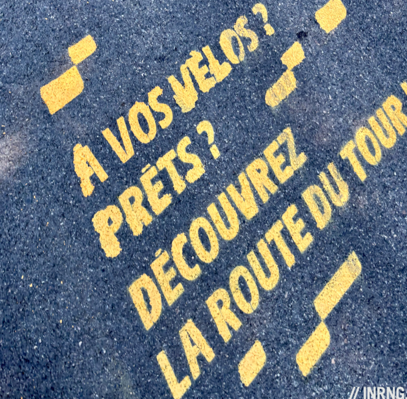
Starting in Saint-Amarin it’s gentle for half a kilometre to the church but “Discover the Tour’s route” is stencilled in yellow on the tarmac, a clue to what’s coming. Soon the slope kicks up to 11-12% as you pass houses where parked cars sit with wooden chocks under the wheels. Don’t be tempted to clear the first this ramp with a burst on the pedals because it only eases briefly and then you face a kilometre of over 10%.
Once you get to the woodland you can shift up a couple of gears. Follow the first hairpin round and ignore the turning for Meerbaechel. From here you’re back in low gears for two kilometres at 10-12%.
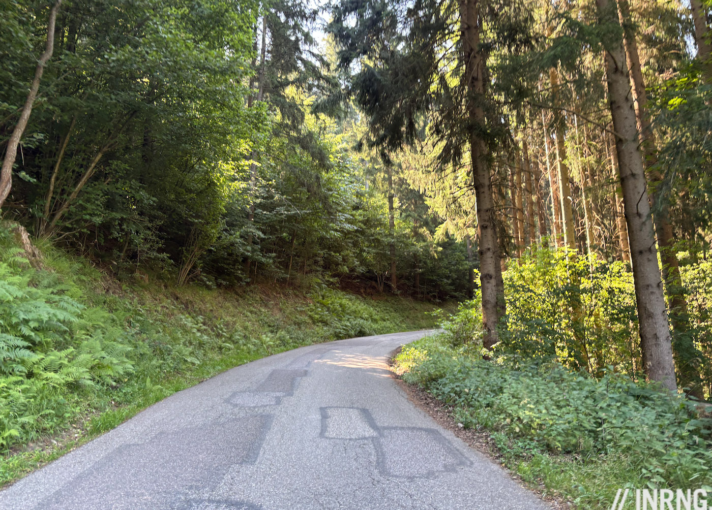
It’s steep but pleasantly shaded. When you see the leafy canopy ending it’s a clue the slope will too. There’s a brief descent to eat and drink but not easy on as the road is bumpy here. You’ll pass a fountain on the right if you want water.
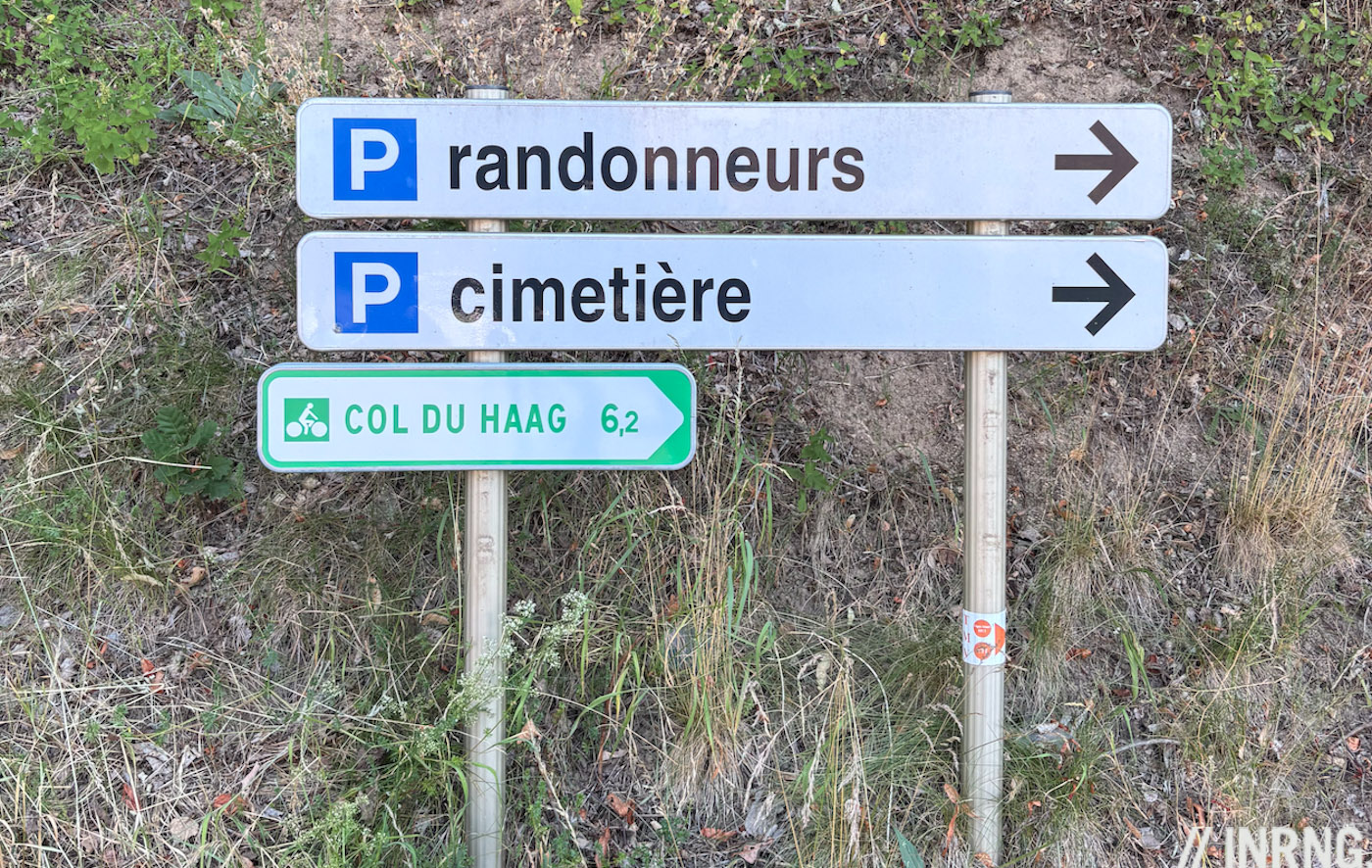
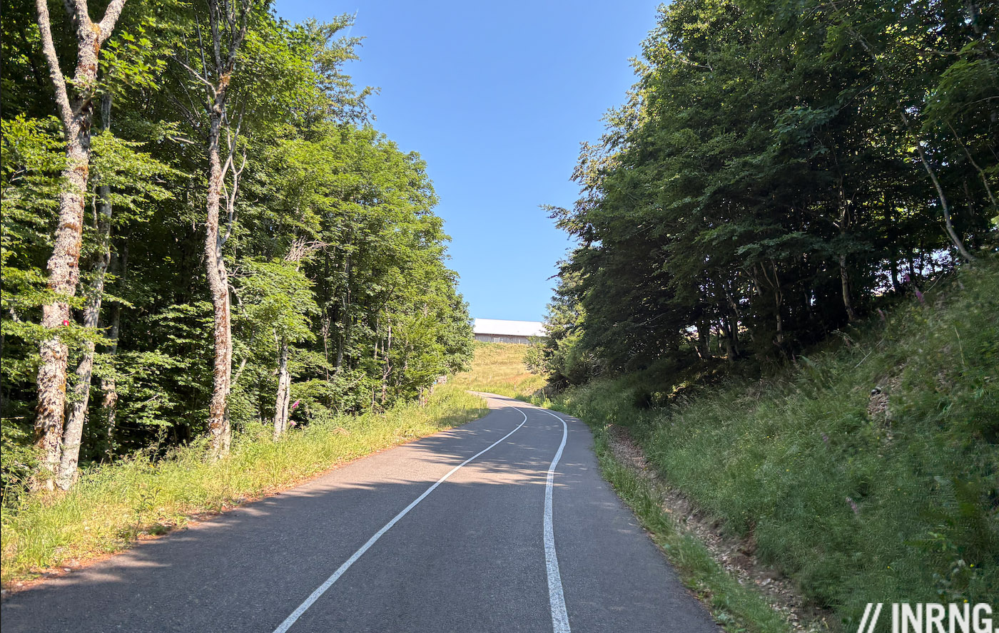
Leaving Geishouse is where the route gets novel. From here the road to the pass is on a dedicated pedestrian and cycle path. Look for the green signage and the turning should be obvious as it heads uphill.
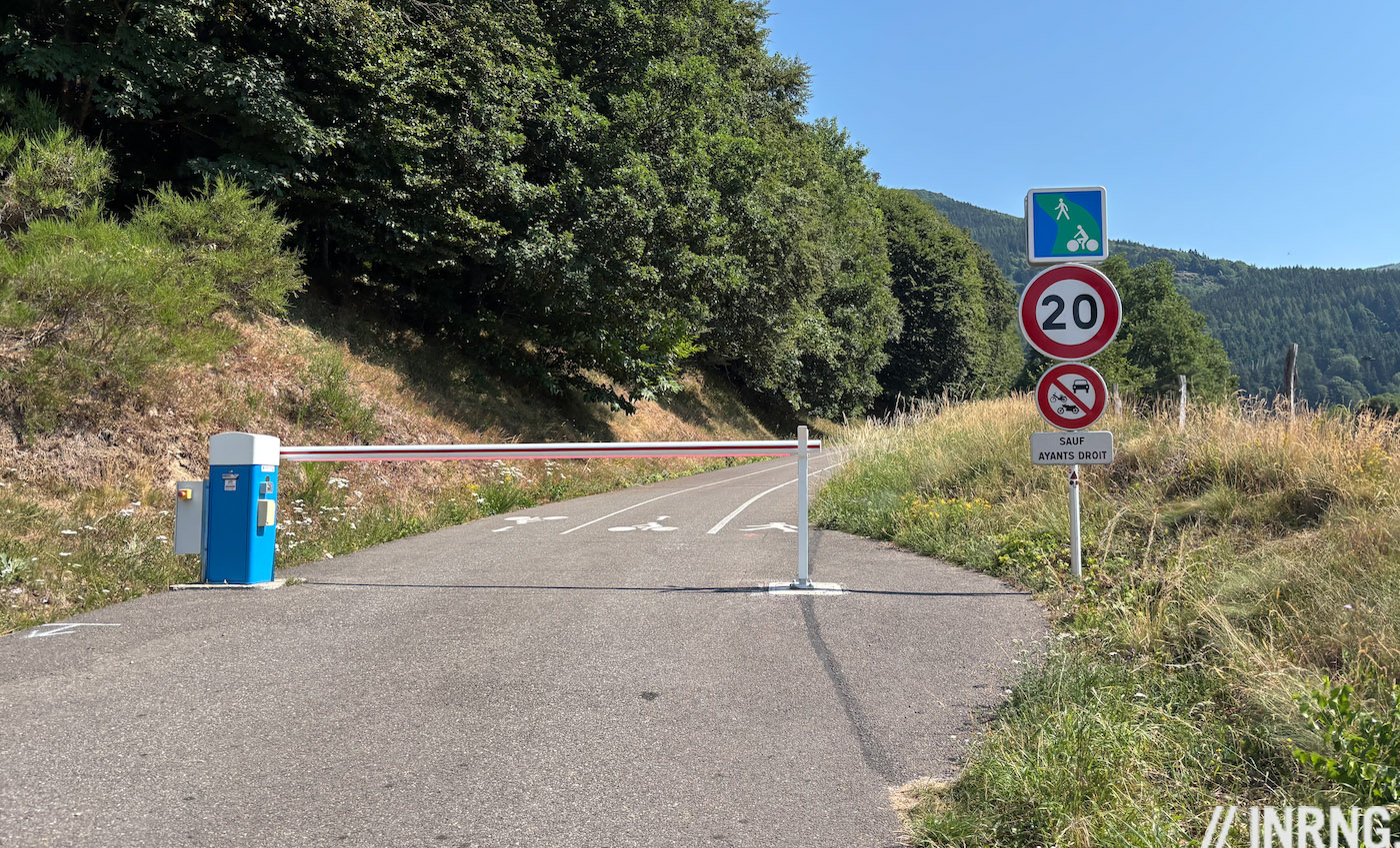
This is strictly closed to vehicles, barring a few locals with a pass. Swerve the gate to find three lanes like an athletics track: left for cyclists coming down, middle for you climbing and right for pedestrians. It’s like this all the way for 5.5km to the top.
On a weekend morning in summer there were no hikers so you’re better off in the pedestrian lane on the right to leave space for those bombing down on a bike. The whole road cycle path is little more than four metres wide.
It’s a steep 9-12% for long sections. But without any abrupt changes and a smooth surface it rolls by well. Despite the Tour de France novelty this path isn’t new and the bitumen has faded grey and already beginning to suffer some gentle frost damage. You can notice these details when it’s 12% for a long while.
Tall pines provide horizontal cover to block views but not always the sun above. After 9km the slope eases long enough to get in the big chainring.
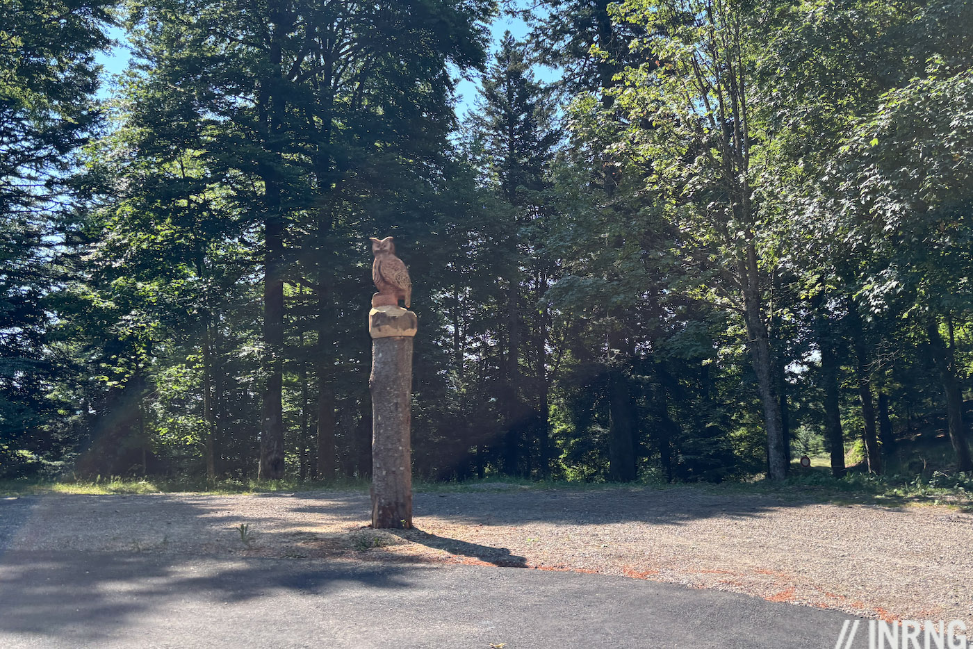
You can speed to the virage hibou (“owl bend”) but shift gears before the strigine carving as the hairpin pivots you into a 12% slope, you can imagine many chains being dropped here. It eases briefly and then the last ramp up begins.
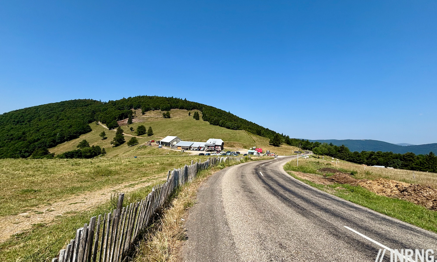
When you spot the farm buildings ahead you’re nearing the top but the final sting is yet to come with a final kick to the top.
The Verdict
A peaceful climb, this is a commendable initiative to give cyclists a reserved route up to the Route des Crêtes. If they had just repaired the road it’d be a nice ride but the real win comes from creating a dedicated cycle and pedestrian route. You get to the Vosges almost all to yourself.
Only it’s not all bucolic forests. This is probably the hardest climb in the Vosges in terms of slope and distance combined, the %2 x km formula. The only negative is the lack of views on the way up but you’ll get plenty from the top.
Advice
It’s better to climb than descend. This is a cycle path and it’s not wide, you can’t carve a hairpin bend and if you come around a corner to find two cyclists side-by-side on their way up, you only have a small space to pass. It’s doable but it just works better going up.
It is steep with long sections at 10-12%. Go equipped with gearing to suit.
It’s reminiscent of the Col de la Loze as a cycle path in the mountains. Only if it has steep moments it’s way more regular and predictable, you won’t be shifting gears and standing on the pedals from one minute to the next.
The farm at the top serves local food. If you want to stop anywhere for a bite or drink, try this place. The better the inn does from cyclists, the more it justifies the cycle path investment and future resurfacing. There’s fleischschnacka and Munster cheese… and blueberry tart.
Ride more
Get to the top and you’re on the Route des Crêtes. You can turn right to complete the Col du Grand Ballon, only only about a kilometre away and about 100m more of climbing. It offers even better views, although with the vibe of a busy car park. Go left and you soon reach the Markstein ski area with several junctions giving you plenty of Vosgian variety.
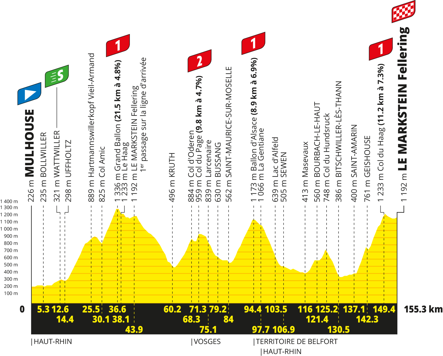
The Vosges are great. This year’s Tour stage can give you ideas: start in Saint-Amarin to climb the Col du Haag, then go left to the Markstein and follow the Tour route via Kruth to Bussang and then do the Ballon d’Alsace and the Col de Hundsrucken to reach Saint-Amarin again after 110km. This route has a mix of major roads and minor ones.
The Alps are near enough to see on a good day, a massive draw with boss-level ascents and breathtaking scenery. Only the Vosges complement the Alps well, a place to try longer climbs and descents if you’re new to riding in mountains but all on a confidence-boosting scale; and if you’ve had your fill of the high mountains there’s plenty of charm too and the ability to construct routes with plenty of climbs and descents in a day instead of just a handful.
Haag History
A haag is a old German word meaning an enclosed or fenced area and there has been a farm here for centuries.
The Tour de France has done the Col du Haag many times but don’t worry if you’ve never heard of it. It’s because the Tour has ridden along the Route des Crêtes, the touristy road than runs roughly east-west along the ridge line. The pass sits near the Grand Ballon and isn’t remarkable when ridden in this direction, just as you may not have heard of the nearby Col du Moorfeld or the Col d’Amic either.
For visiting cyclists, walkers and motorbikers the farm at the Haag has been a stopping point for snacks and a view. It belongs to the village of Geishouse below and there had long been a path up. In 1960 this trail was tarmacked and but gradually fell into ruin. It ended up the preserve of local hunters in 4x4s, motorcyclists with adventure bikes, and gravel bikers.
The mayor of Geishouse wanted to repair it but at €400,000 the cost was exorbitant for the locals. So he hit on the idea of making others pay. In another story of France’s layercake local government, he pitched a cycle path tourist attraction. In came funding from central government, the region, the départment and several nearby towns totalling €600,000.
Some locals objected saying the road would be closed to them at the expense of visiting cyclists, it’d be a long detour to get to the farm. The solution was gates where some locals get pass to operate them so if you spot a car it’s probably legit. The road was fully resurfaced in 2023.
When to visit?
People living within half a day’s travel – the area is popular with Dutch and Belgians – could spot a warm weekend in March or April to tackle some climbs but otherwise mid-May to October is ideal, it’s busy in July and August with holidaymakers.
Travel and access
Basel in Switzerland probably has the best travel connections with air, road and rail, it’s a hub sitting between France and Germany but it’d be too far to ride out from each day. In France Mulhouse and Colmar are the nearest cities but sit on the plains and require a ride.
For the Col du Haag towns in the Thur valley like Fellering, Saint-Amarin and Thann make for a good base and are served by rail.
More roads to ride at inrng.com/roads
Great artical Thank you Mr R
Rode what is now the bike path in 2020 when it was still a very dilapidated forest road (with a slight variation in that I got up to Geishouse from Moosch). I wasn’t expecting such a bad surface, although the slight bonus was that concentrating so much on picking a route, took my mind off the gradients…bit like the gravel on the Finestre!
Good development I reckon.
For everyone interested there is a road up from Moosch too, the next town in the valley, which reaches Geishouse too where the cycle-path begins.
Interesting read, thank you
The Vosges and the area around Mulhouse are an underrated cycling area! Not only for the climbs described in this article, but also if you want flat TT training grounds, there are small roads along the rhine river without any cars which go 10km in a straight line. If you want climbs, there are plenty Haag style climbs on small roads all around. And if you have done them all (unlikely), you can ride over the the Black Forrest on the German side, which has the same setup all again (small, well paved roads, very little traffic). Its a 30-40km warm up from Mulhouse, for example. Great area for cyclists!!
When I did a similar piece for the Petit Ballon climb (https://inrng.com/2023/07/roads-to-ride-col-du-petit-ballon/) readers also suggested Germany too so worth mentioning.
Talking of training, the Ballon d’Alsace on the Tour route, climbed from Bussang, is a great training gym as it’s so even and steady, no hairpins to ease into or attack, no recovery moments. You could do this on a home trainer or come here for mountains and views.
I’d suggest staying in Munster rather than Colmar (and maybe catching the train to Colmar or even Basel via Mulhouse on a rest day). It’s a lovely small town. I visited quite a few times when a friend was working as an English teacher there.
Munster is a good base, plenty of climbs within reach, scenic etc and has a rail connection.
I was never a fan of steep mountain length descents. The fun wears off quick as it becomes a long concentration session of braking. Looking at the map i would prefer to come down on what looks like a main road if its safe. I but do approve the cyclist only aspect.
I laugh at the 600k euro figure. Wouldn’t get you diddly squat in Australia. In this state the construction union would expect a greater cut than that just to allow the project at all.
My suggestion is the other roads off the mountain are better for descending, wider and faster for the corners but with a decent surface and more like 4-6%. There is traffic, especially at weekends, but more like groups of motorcyclists, you can go minutes between seeing other vehicles. Plenty of cyclists too.
For anyone interested in cyclosportives: the climb to the Col du Haag described here is part of the L’Alsacienne cyclosportive (https://www.alsacienne-cyclo.org).
All five route options offered (ranging from 56 km to 195 km) include this climb.
This year’s edition was scheduled for last Sunday but was cancelled due to the heatwave. Otherwise, however, it is a truly wonderful event set in a beautiful region.
“After 9km the slope eases long enough to get in the big chainring.”
Would that not be a blasphemy for the author of this blog? 🙂
Ha, no mono chainring here for sure.
Do they have some carpe frite in the inn at the summit ? Ate this once in Altkirch, never again… Alsatian cooking is really worth a try (but maybe not so cycling-friendly).
Don’t scoff too much tarte flambee at lunch or you’ll be carrying a few extra kgs for the rest of the ride!!!
Try baeckeoffe, or choucroute.
That’s probably more to be found elsewhere, down in the valleys. Have seen cafes with menu boards outside offering carp.
strigine 👌🏼
Any advice, where to park the Camping car for this climb to Col Du Haag?
Thanks
No, but the foot of the climb is where the tourist office is from memory and if you ask and say it’s for the climb they’ll know and probably be delighted to know you’re coming for the climb.
Should be interesting if someone has a mechanical and needs a team car during the climb.
In Swedish “hage” has the same meaning as “haag”.
On having a mechanical:
The route will be one-way for the race, and should be able to take a car since it is 4m wide and cars are typically about 1.8m wide. It might be difficult for the cars to pass each other though.
Does haag roughly translate as paddock in English? It is an enclosed/fenced area used for pasture.
So having car number 1 in the convoy will be an advantage.
From https://www.wisdomlib.org/ on Haag
Historically, this term often referred to a forest clearing protected by a thicket or a wooden palisade. In the context of German toponymy, such names frequently denote a settlement established within or adjacent to a fortified woodland boundary. Grammatically, the name is treated as a neuter noun, and while it is a common element in many German place names (often appearing as a suffix), as a standalone name, it identifies a locale defined by its medieval defensive origins. Synonyms or related topographical terms in German dialects might include Hagen or Gehege.
The history of Haag is deeply intertwined with the former County of Haag (Grafschaft Haag), a historically significant sovereign territory within the Holy Roman Empire that maintained its independence until it was absorbed by the Duchy of Bavaria in the 16th century. The town is home to the remnants of the Haag Castle, which served as the seat of the powerful Counts of Haag. Today, the region is a popular destination for those interested in Bavarian history and rural culture, characterized by its rolling landscape and traditional architecture. A notable cultural feature is the Haager Herbstfest, a traditional folk festival that draws significant regional attendance. The area is also known for its well-preserved historical town center and proximity to the scenic Inn Valley, offering visitors a glimpse into the aristocratic heritage of the former Imperial County.
Ahh, so the hedge/fence wasn’t to stop the animals wandering off, but to protect the settlement itself. Is this right?
I think it’s ended up as ‘hedge’ in English; the means of enclosure rather than the enclosed area
Ahh, that is interesting. Thanks for that comment.
This is great. Thanks for the interesting details.
Another option for staying would be Gerardmer and Longemer which also gives you access to a couple of lakes if you like swimming (which we do). There’s a road up to Le Markstein (we happened upon the Tour d’Alsace by accident) and there’s the climb the Tour did in 2014 whose name escapes me.
Mind, it rained almost every day in the middle of summer (and hammered down on the Tour). There’s a reason why there are forests around there.
These are my favourite of all your articles. Thank you so much for this and all your Roads to Ride, they are all so evocative and brilliant