
Scenery, altitude, length, gradient, little traffic and variety: the Cormet de Roselend has it all. The only thing missing is celebrity status. The Tour de France has only used it a few times for the blunt reason that the pass was only tarmacked in the 1970s.
 The Route: the D925 climbs east out of the town of Beaufort in the Savoie départment of France. It is 20.3km long and climbs to an altitude of 1967m with an average gradient of 6%.
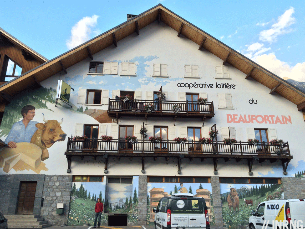
The Feel: Beaufort is a real place rather than a synthetic ski village or a dusty crossroads. It’s famous for its eponymous cheese which is better to sample after a ride than before, especially on a hot summer’s day. The town’s dairy (pictured) is the starting point for the climb.
The ascent starts with cobbles. It’s hardly Geraardsbergen but the traffic calming stones will rattle lightweight climbing wheels. It climbs immediately out of town and on a hemmed into a steep-sided valley flanked by dark pines. Their shade and the river help cool on a hot day. You’ll soon spot the marker stone for cyclists indicating 20km to go, there’s one every kilometre from here to the top. The road is wide. It’s not busy because it barely leads anywhere but in summer, as part of the Route des Grandes Alpes it has its share of touring motorists.
After five kilometres the road zigzags up the side of the valley wall to escape the confines of the valley and you begin to get views looking back down towards Beaufort. Forest tracks join the road and milk churns sit in the shade awaiting collection by the dairy. From here on you may see more cows than people as the road has very few buildings along the way. At the 12km point comes an intermediate pass, the Col de Méraillet and then you round a bend and suddenly the landscape changes.

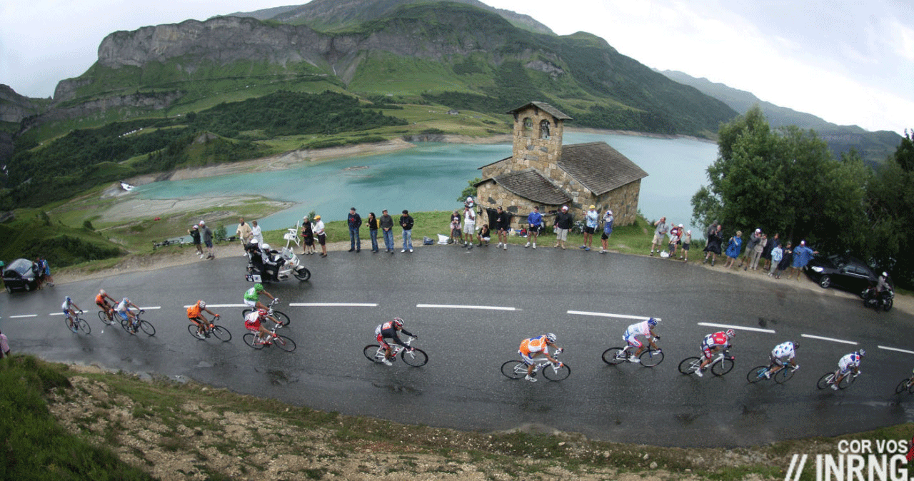
The road runs around the scenic Roselend lake for over two kilometres. Moments ago you were in a V-shaped valley, now the view runs expansive and if the weather’s good the lake’s opal waters reflect the peaks around. There are a couple of restaurant and cafés by the road plus the small Roselend chapel, all that remains of a submerged village after the hydroelectric dam was created in 1960 and the artificial lake created. Look up and amid the peaks you can see the road bend around the rocks above the treeline.
Circle the lake and the road climbs up again. That 6% average gradient you read about makes the climb sound easy but once you account for the gentle 2.5km descent around the lake the rest of the climb is 8% for a lot of the time. Geologists will appreciate this section as road bends around dark shale rock, some of which litters the road surface as the road bends around to put the lake out of sight. Now begins the final section, three kilometres in open terrain with grassland and a river whose clear water looks tempting if you’re thirsty but wait as there’s a small chalet with a fountain outside ahead.
The gradient eases and after a few more bends and the pass appears. The top is a large open area with the col sign and no more than a dirt parking area. You can continue down the other side on an open and fast descent where the road is the only sign of human activity for a long way. Keep going to do a 125km clockwise loop back to Beaufort via Bourg-St-Maurice, Moutiers and Albertville although the Cormet’s climb is the highlight.

The Verdict: at 20km this is a long and significant pass and if it almost reaches 2,000m the lake section along the way allows for recovery and the soft gradient for the final kilometre should allow you to finish with some energy to spare. Even amid the verdant northern Alps it’s especially scenic thanks to the cows and their bells, the vast mountain lake and the open expanse towards the top of the climb. It’s peaceful as the traffic is light. But there’s an even better way to climb it…

Ride more: there’s a second way up out of Beaufort via the Col du Pré (“Field Pass”), a hidden gem of the Alps. Look for the sign to Arèches and once you reach this village look for the Col du Pré signs. From here on it’s a small, steep road with 10-11% sections and 26 hairpins for the next 12km. These bends lend a feeling of déjà vu because you just rounded a hairpin next to a barn and then you round a hairpin bend next to a barn and so on. The views are the stuff of postcards with green pastures and pyramid peaks. As you approach the top you’ll cross the col and get views of the lake. A quick descent and you ride along the dam and can continue climbing to the Cormet.
Cormet de Roselend? Cormet is local word for a summit and Roselend (not Roseland) was the name of a village that has been submerged below the lake following construction of the hydroelectric dam.
History: the route is ancient but the road itself is almost new as it was only tarmacked in 1970 which explains plenty. For starters there are few buildings along the way and also the Cormet isn’t a staple of the Tour de France having only been climbed nine times, first in 1979. It’s a transitional pass rather a summit finish and so rarely decisive.
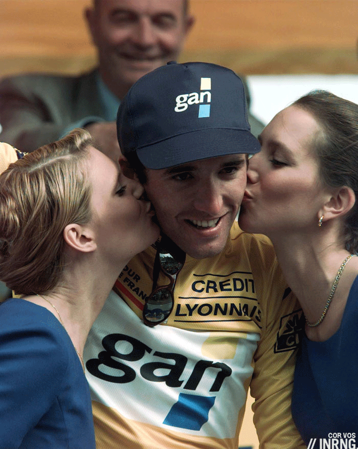
It mattered in 1996. For years Stéphane Heulot had spent July on the slopes of the Cormet de Roselend because he hadn’t been selected to ride the Tour de France and so he took off the Alps to combine a holiday with a training camp. In 1996 he turned 25 and finally got the call to ride the Tour with his GAN team and having gained time in a breakaway during the first week he took the yellow jersey as the race entered the Alps. Only come the stage over the Cormet de Roselend – his climb – he was forced to abandon with a knee injury while wearing yellow. Was he going to win the Tour? Never but this was a sorry way to quit.
Travel and Access: the autoroute network runs past nearby Albertville, high speed trains run to Chambéry and the nearest international airports are Lyon and Geneva (Switzerland). Beaufort would make a good hub for a week’s riding with several passes from the famous to the fiendish.
Definitely a road to ride! And yes climbing over the Col du Pré is even (considerably) better although harder depending on your bike’s gearing.
I struggled when reading “anti-clockwise” and rightfully so. The loop you describe runs clockwise, at least on a map where North is up.
I would rather climb up to the Petit St. Bernard then descend towards Sainte-Foy-Tarentaise and the do the Cormet the other way up to get back to the Beaufortain.
You’re right, clockwise it is. Glad to see agreement on the Col du Pré, hopefully readers try this and enjoy it because it’s not famous at all for racing. The Tour de l’Avenir used it recently though.
The 1996 Tour stage that climbed the Roseland was famous for two reasons beyond Heulot’s abandon. First, Johan Bruyneel crashed descending the Roseland and he ended up falling into a tree-lined gorge. There is a famous picture from L’Equipe showing him climbing out of the ravine. The descent was followed by the finishing climb at Les Arcs. Second, it was the day that Indurain cracked and effectively lost the Tour on the summit climb to Les Arcs. I was there that day on a bike tour. We climbed the Roseland in the rain just before the stage came through that day. So cold at the top that we put plastic bags over our shoes to keep a bit warm. Almost wiped out on the descent as the road was like ice. Had to be pulled off my bike at the bottom of the descent because I was too cold to get off of it. Coldest day ever on my bike. Sat in a van to warm up then walked up Les Arcs to watch the race finish, it was sunny and pleasant by then. Remember seeing George Hincapie in the back with the sprinters slogging up the final climb. I still have the Equipe edition from the next day showing Bruyneel and Indurain.
The image of Bruyneel was a famous one, sounds like a grim day to be in the race or beside the race.
Was lucky enough to ride this (but from Bourg St Maurice) in July 2016 with a great friend. Added in the little loop to the Col du Pre and had dlunch before heading back.
Whilst in the area also added in La Plagne and back via Core d Aime.
Brilliant.
The Cormet was in the 1992 epic win of Claudio Chiappucci. Then in 1996, as many mentioned, saw the episodes of Bruyneel and Heulot, but also the wet glasses of Zuelle and the first bad day of Indurain
I don’t know if this has been mentioned in any of your previous Roads to Ride articles, but I’ve just found that Google Maps’ Street View is a great way to follow your climbs.
I love reading about them, but Street View brings your stories to life. I’ve just spent a considerable amount of time “climbing” both Cormet & Col du Pre, & the scenery is stunning. Certainly not the same as climbing them in person, but the images have added a new dimension.
At the summit of the Cormet a lone rider is approaching from the Bourg-Saint-Maurice side, and the image is so clear that I’m sure they could identify themselves. If you were riding the Cormet in July 2013, check it out.
And interestingly, the sign at the summit lists the altitude as 1968m. What’s one metre when you’re climbing at this altitude?
I’ll certainly be re-visiting many of your Roads to Ride stories, accompanied by Street View, & I’m looking forward to climbing many of them in person in the years to come.
A huge thank you for this great site.
at the foot of the roseland as you describe it is the hamlet of les Chapieux leading to the Valley of the glaciers. Only inhabited in summer it is la france profonde or rather le Savoie profonde. And formerly the base of the 22nd Chausseurs Alipin.Great cheese shop . Meals drinks and overnights at the auberge de la glacier or overnight at les chambres de soleil, or the big free camp ground, loads of campervans in summer,
A fantastic ride from either side with a descent that will catch the over confident or unwary. Michael Rogers abandoned after crashing on the descent to Bourg some years ago. Yet on a sunny day there are alpine flowers and little traffic. This an area that is littered with climbs. The Cormet can take you to Beaufort then over Le Saisies to Flumet/Megeve or to Bourg and the Tarentaise with the 40km climb to the Iseran or over to Italy via La Thuile
Did the main route described by inrng in 2014, as the weather was murky in the morning and the promise of a Mont Blanc view from Col du Pré thus broken. It dried up and the section from the lake and up was plainly wonderful. The descent to Bourg may be the funniest 20 km I’ve ever done, with the extremes of the dead straigtht 90 km/h sections to ravine terrain with unpredictability rivalling the Col d’Allos down to Barcelonette.