Famous for its tyres, the French manufacturer hit upon the idea of encouraging the growing class of motorists to travel with a series of tourist guides. This spurned the imperious restaurant guide, where chefs have killed themselves after unfavourable reviews. But there’s also a series of maps.
The series of folding 1:200,000 maps are excellent for exploring France (and other countries). You get one per area of France, usually enough to cover a full day’s riding in any direction so long as your start point isn’t on the edge.
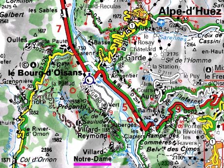
For me it’s the clarity of the maps that wins. You can see the terrain but it’s the way the roads are depicted that is so useful. Big red arteries are the trunck roads, the red is like a warning sign that you’re going to be sharing the road with trucks and high speed traffic. Yellow suggest a smooth road, often engineered in places to level gradients and wide enough for traffic to pass a cyclist. The white roads vary, the wider white strips indicate smaller routes and the narrow white lanes suggest a lottery, sometimes the most stunning roads of France, other times pot-holed farm tracks more suited to a mountain bike and impractical for a training loop.
Look closely and you get other features. Gradients are marked by arrows and often the altitude is displayed. Also there are numbers in between waypoints to let you the distance, for example it’s 5km from Bourg d’Oisans to Les Clapiers, where the sharp bend in the road marks the start of the Col du Lautaret.
With a bit of practice you can learn to read these maps and get a real feel for the terrain ahead. In an age of GPS and Google Earth the traditional paper map can still be very informative.
The other remark is that the maps are partly so good because France has such an extensive road network. There are apparently 900,000km of roads in France, riding all of these is the equivalent of pedalling 23 times around the world.
Photo: Steephill.tv (great article, worth a read)


The paper maps are great when in France in a remote place but they are also available online – eg. http://www.viamichelin.com/web/Maps/Map-La_Garde-38520-Isere-France?strLocid=36NDJpMm01bW16cXU2MjhmNGlyNjMycnpkazAxMDEwY05EVXVNRGMwT1RnPWNOaTR3TmpNek1nPT0=&loc=no&layers=000001&zoomLevel=12&strCoord=6.076283339749361*45.07789862077115
These maps saved our hides when racing/training in Europe in 91. We didn't go anywhere without the appropriate one.
Ah yes, always like to get a michelin if available, still got my 1970s brittany map but more recently majorca, ibiza,costa brava,alps and nice area (cote de azur?)