

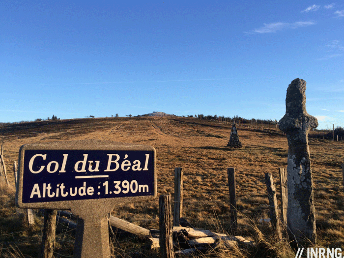
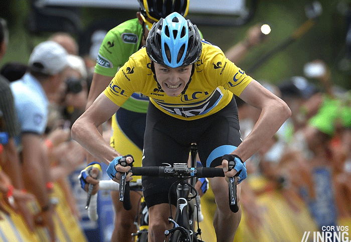
The Col du Béal in central France isn’t a famous place for cycling history. But it’s on the map thanks to the duel between Chris Froome and Alberto Contador in the Dauphiné, one of the season’s best battles. It is a rewarding climb in a great, but often forgotten, part of France.
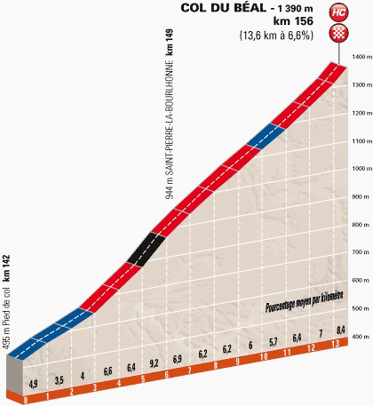
The Route: there are three main routes to the top and this post looks at the “Dauphiné” route from Vertolaye in the Puy-de-Dôme department of the Auvergne region in central France. It scales the western side of the climb starting with the D268 before picking up the D40 at the crossroads called Les Granges, passing through Saint-Pierre-la-Bourlhonne on the way to the top. There’s no mistaking the climb as at a single junction it’s possible to see three signs showing the way, one main for the Col du Béal another for the Le Béal Nordic ski area and a third in green marking a cycling itinerary.
Other routes: As a large mountain the pass itself is one road but the further down the mountain you go the more dendretic the road network with junctions, forks and other choices.
The Feel: the Dore Valley is a case study of decline. Old mills crumble, houses sit empty, the railway’s lost its regular service and the main road is wide but drained of traffic by the A72 and A75 autoroutes which run parallel roughly 50km on each site, symbolically and literally the world is passing by this area. All the better for cycling? Perhaps but it’s hard not to feel the melancholia, a sense that the past was a better place than the future. At the foot of the climb pharmaceutical giant Sanofi is the largest employer, its factory is Europe’s largest source of, ahem, cortisone.
The road quickly climbs above the town. It’s lush with chestnut woodland and ferns for undergrowth. The road is irregular, never that steep but over, say, a 500 metre section the gradient can go from 3% to 7% to 5% and to 8%. Averages are meaningless.
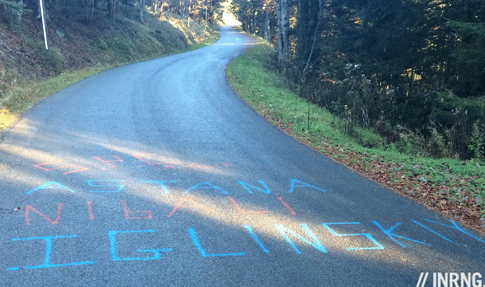
Higher up and the sun sits low in the sky, casting a long shadow that looks like a long-limbed rider is alongside me. Is it Chris Froome? Am I Alberto Contador? Actually the road’s pro references are kept to a minimum on this climb, during the 13km ascent only two pieces of road graffiti were visible, one “Allez Voeckler” and tragically someone had painted “Iglinskiy” in Astana blue on the road.
On the right a large TV aerial and military communications base are visible. You might think it’s the summit, a bit like Mont Ventoux but this comes well before. A wide bend, too gentle to be called a hairpin and a sign saying Grange Neuve or “New Barn” marks the place where Froome started his series of attacks on Contador. Here the road is flatter and more linear. Television often fails to convey the gradient only this time it looks as gentle as the video suggests and from here it’s not so steep and soon the finish comes into a view with a lone building sat at the top. There’s a water fountain if it’s a hot day and you want to fill up your bottles.
The History: it’s only been used twice in racing with the Tour de l’Avenir in 2010 and the Dauphiné in 2014. Both races have left their finish lines at the top, the paint still visible. This year’s racing was a pick among the highlights of the year. In 2010 Belgium’s Yannick Eijssen won the stage, adding to other prestigious mountain stage race wins like the Ronde de l’Isard and a contract with BMC Racing followed. But corresponding results in the pro ranks haven’t followed and maybe he’ll reset things with a move to Wanty-Gobert for 2015.
The Future: there’s a pattern of roads appearing in the Tour de l’Avenir, the Dauphiné and then the Tour de France. Could this be part of the 2016 Tour de France? It’s a 2+2=5 guess but would make sense given the Puy de Dôme is off-limits to cyclist so this climb could replace it as the region’s best ascension. One problem is the region’s isolation, population density is low and even the Tour de France might feel silent as it climbs this road.
Travel and Access: Clermont Ferrand is the nearest city and served well by road links but less so by rail and there’s no meaningful air access. The region offers plenty of climbing in the Massif Central range including across an extinct volcanic chain with still obvious cone-shaped peaks.
More roads to ride at inrng.com/roads
Lovely part of France and another good review. I particularly like your description of the melancholy nature of this forgotten and decaying rural community. Out does beg the question: What is the future of these less-than-well-connected parts of such a big geographical country? Sorry, my day job as urban planner taking over now… back to the bikes.
It’s difficult, the towns in the valley sprung up with the work but now the jobs have gone the reasons to live there dwindle. There’s a lot of crumbling houses too which all suggests people are simply moving away to places with jobs, connections and more.
* It, not out “begs the question” – sorry, my typo.
Being pedantic, “begs the question” does not mean what you think…
Philosophical heckling is so rare these days *applause*
Astana, Iglinskiy – I’ve heard of him !
:o)
Is there a TUE dispensing kiosk at the foot of the climb as well?
I didn’t see a TUE kiosk but I did see reports in the local press of “mutant” fish, with claims the Dore river is contaminated by hormones and steroids from the factory.
Did the Astana Pro Conti team stay at a local hotel ?
Ha Ha “Simpsons” like images filling my head.
This place is very rural indeed have done quite a bit of cycling around here, tried to ride the pud De Mary and it was still impassable in May!
The weather here turns on a sixpence … great
I happened to drive up the Col du Béal last December to go for a walk in the snow up to and beyond the radar station at Pierre-sur-Haute. On the way up I was wishing that I had my bike with me because it seemed like it would make a special climb and a fun descent. In fact, the whole of the Auvergne region looks like it would be an excellent cycling destination with a real mix of terrain. It obviously works for Romain Bardet. Being a rather unheralded area means that it’s also excellent value.