
As the next in the series of famous roads to ride, here’s a trip to the Beaujolais hills in France for the Col du Pin Bouchain.
“Col what?” you may ask. The Col du Pin Bouchain holds a unique place in cycling history as the first pass ever climbed by the Tour de France, at least that’s what historians think. Given its location and history it should be something special but it turns out to be a road that’s nicer to read about than ride, a place where the past was probably better than the present.
The Route
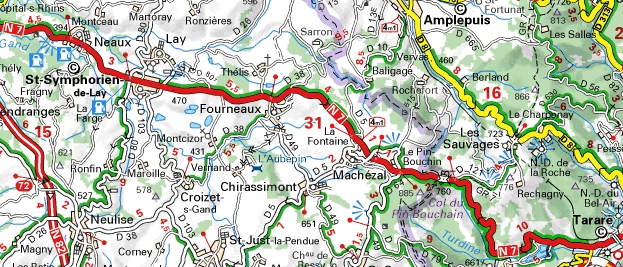
There’s no obvious start point as this is not a high col that tackles the flanks of an Alpine valley. The Nationale 7 starts climbing out from the town of Saint Symphorien-de-Lay, leaving about 12km to the top. Most of it is uphill at a steady gradient, typically 3-4%. The village of Fourneaux includes a large bicycle memorial by the road from 2003 celebrating 100 years of the Tour de France. The top is marked by a large black sign to indicate the col. From the other side, the road is more scenic and steeper as it climbs up the Turdine valley from Tarare.
The Feel
It’s a red road on the Michelin maps, a major traffic artery but construction of the A7 Autoroute has drained away a lot of traffic leaving Saint Symphorien as a relic to the past, a place that grew up because of the road, and now crumbles beside it. The road itself is fine but many houses along the way are closed, their steel shutters rusting in the traffic fumes. The sight of a giant frying pan beside the road hails the world record attempt for the biggest omelette. It sounds festive and eccentric but celebrates a feat achieved in the 1980s and vibes a melancholic place clinging past triumphs no matter how trivial.
This is still a main road, indeed works have been done to speed it up. You can spot the route of the old road that once meandered up the hill by rows of houses and their faded paint advertising aperitifs and hotels for passing motorists, hopefully they made use of the latter if they tried the former. But the N7 has been engineered to cut straight through, a tarmac canal. This has only made the traffic go faster and riding up you feel your shoulders tensing up as another truck roars past, the gradient is not enough to slow them. The local newspapers are full of grizzly road accident reports, a staple of the French regional press. Search online for images of the mountain pass and mangled vehicles galore come back.
Nevertheless this is a real climb and a proper col. There are a good views across the top to the north of the Beaujolais and the summit marks the demarcation between the Loire and Rhone départements as well the watershed point between the Atlantic and the Mediterranean.
The History
This is a route that has existed since Roman times to link Gaul to Rome and later became the main route between Paris and Lyon. Saint Symphorien was home of the Logis Tête Noire, a postal relay and inn that hosted travelling kings, popes and more over the years.
The pass was known as the Col de la Chapelle and in 1536 King François had dinner with King James of Scotland where legend has it the French monarch gave away his daughter in marriage to the Scottish King, sealing a diplomatic pact. After 1789, revolutionary fervour saw the name changed to drop the religious tones. It seems the col was topped by a pine tree and the Bouchain family once owned the land around the area so “Pin Bouchain” arrived.
In 1835 it was incorporated in the Route Nationale 7, France’s longest highway linking the Paris to Menton on the Italian border and for years a getaway road linking northern Europe to the Mediterranean coast, France’s Route 66 if you like. In post-war France it became the scene of a thousand holiday traffic jams, misery yet often evoked in films and witness to rising wealth and mass consumption as people bought cars and the roads became lined with advertising. This is all in the past with the advent of the nearby autoroute.
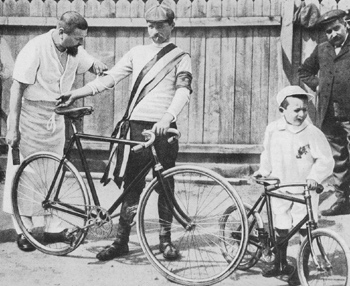
The Tour de France crossed in 1903 on its opening stage from Paris to Lyon, a 467km journey that took stage winner and eventual race victor Maurice Garin nearly 18 hours to complete. This seems to be the settled version because reports said the nearby Col des Écharmeaux could be on the route of the first stage but after the riders passed the last checkpoint in Roanne it would have been two sides of a triangle to do the Écharmeaux, going over the Pin Bouchain made much more sense. Indeed a report from the time said a telephone call from Tarare, at the foot of the descent, signalled Maurice Garin has passed through early in the morning.
Next Tuesday the Dauphiné will climb the Col des Sauvages before descending into Tarare for the stage finish. This route runs parallel to the Col du Pin Bouchain, just 3-4 kilometres away. You can’t help feel ASO missed a trick here to make an early celebration of the 100th Tour de France but the N7 is probably too big a road to close for the afternoon.
The Road Not To Ride?
Of all the roads in this series this is one not to ride. It gets a mention for history’s sake and is included now because the Dauphiné passes so close. But while its fame lives on or at least it has a place in cycling history trivia, there are better roads to ride. It’s not so much the danger, just the traffic is unpleasant and it’s not a rewarding challenge.
It’s a lesson that just because a road is famous because of the Tour de France it doesn’t always equate to a good ride. There are some climbs in the Alps that are paradise when the roads are closed but infernal for the lone cyclist or small group to try. The Col du Lautaret is one example, the mighty Iseran another.
But if this road is one to avoid, the rest of the region is great for cycling. The Beaujolais Vert is rural France at its best, warm in the summer and with a big road network that apart from the obvious arteries is the kind of place where you’ll find more tractors than cars. It offers plenty of roads to ride, including many cols that top out around 800 metres above sea level meaning a ride in the area can include a series of climbs.
Access
It’s a short distance to the west of Lyon, France’s second city which is served by air and high speed rail links. Places like Tarare and Amplepuis have seen better days but you’re visiting for the riding rather than hoping to find a job and they remain scenic and discreetly geared up for tourists.
More roads to ride at inrng.com/roads
Since you say it’s not the road to ride, may I offer a Beaujolais route for the Col hunters.
First, the region is beautiful. Vineyards, and plenty of small very quiet climbs with Cols everywhere. A kind French friend took me on a 16 Col loop last year. Very fun and not quite as hard as it sounds.
http://www.cycling-challenge.com/col-hunting-in-the-haut-beaujolais/
Impressive, more cols than a French shirt factory.
Love this series, you should write a book of them.
tee hee!
You’re right about L’iseran – absolutely heaving with traffic in the summer, as are most of the ‘famous’ climbs; motorcyclists especially are drawn to them. Still, there’s plenty to take your mind off it – like pain, for example!
Most of the famous French Alps climbs now have a day where the roads are closed to cars – usually a weekend morning.
Savoie Mont-Blanc region
http://www.savoie-mont-blanc.com/Magazine/1-jour-1-col/Les-cols-2013-1-JOUR-1-COL
Hautes Alpes:
http://www.decrochezlalune.net/les-cols-reserves/
Cycled a few last year including Iseran. Was fantastic seeing all the motorcycles stuck waiting at the bottom of the south side as I descended turned around and cycled back up in silence. Always a good ambience at these events.
Good piece. I like the picture of the old painted advertising on the sheer house wall. It’s like the old Citroëns…. there was something charming and good-humoured about mass capitalism à la française as it was in the 50’s. Some kind of style of innovation got lost in France, probably in the 80’s, but what exactly was lost, I guess the French don’t even know it themselves.